
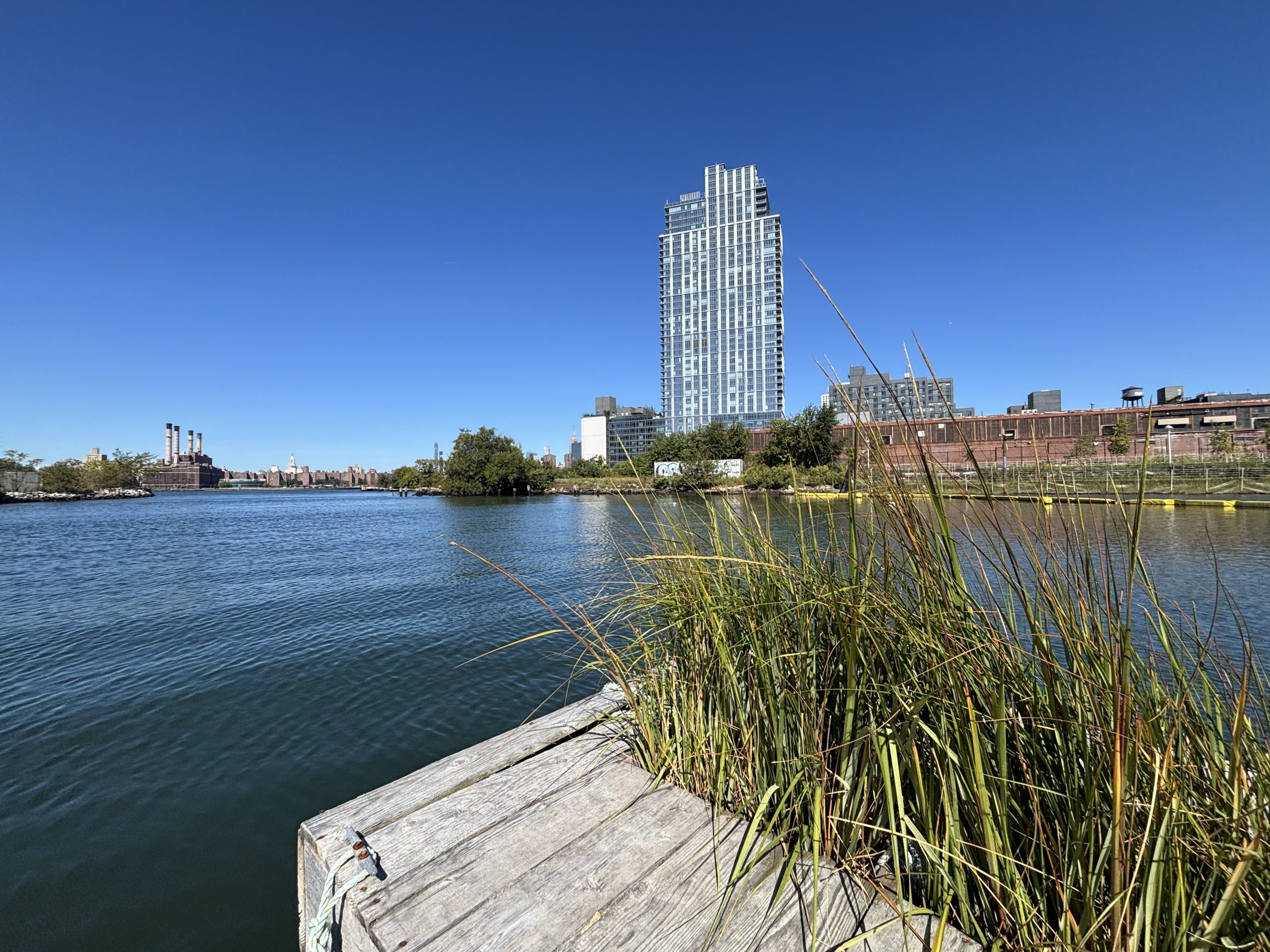
Bushwick Inlet in 2025. Photo by Geoffrey Cobb.
By COLE SINANIAN | news@queensledger.com
If you were a Dutch sailor who regularly traveled up the East River circa 1660, you would’ve grown accustomed to passing a strange, grassy spit of land jutting out into the brackish water to your west, just south of what is today Bushwick Inlet. To the east, a densely forested island that the Munsee Lenape people called Manaháhtaan.
This spit of land, a key landmark to passing Dutch ships, earned the larger peninsula it extended from the nickname “Greenpoint.” Inland was a marshy wilderness of bears, wolves, salamanders, turtles and mountainous colonies of clams and oysters. Prone to intense and frequent flooding, this swamp was, for many centuries, traversed via canoe only by the Mespeatches clan of the Keskachaugue tribe, who lived primarily atop the hill that is now Mt. Zion cemetery (the word “Masepeth” comes from “Mespeatches”). Greenpoint was their hunting ground; the Mespeatches wouldn’t dare settle a place so waterlogged, a place that, during intense rains, would flood completely, then, once the waters receded, leave an odor so fetid that the Mespeatches referred to it as “The Place of Bad Water.”
“The Native Americans were onto something,” said retired high school teacher and historian Geoffrey Cobb, at a December 3 event called “Secrets of Bushwick Inlet,” held at the Greenpoint Library’s Environmental Education Center. Originally from Northern Ireland, Cobb wrote a book called “Greenpoint Brooklyn’s Forgotten Past,” and has become in the 30 years he’s lived here a preeminent authority in local history.
At Secrets of the Bushwick Inlet, presented by a community group called Save the Inlet, Cobb’s presentation functioned as a kind of parable, a long-forgotten story whose lesson is more relevant now than ever. As the City prepares to rezone a plot of land immediately adjacent to Bushwick Inlet to allow for the construction of the Monitor Point residential towers — of which the tallest would rise to more than 600 feet — a chorus of critics including Cobb, Save the Inlet, and Friends of Bushwick Inlet Park are sounding the alarm, arguing that residential towers in the flood zone of a city that’s expected to see as much as 6.5ft of sea level rise in the coming decades is a recipe for disaster.
“We still have issues today with flooding,” Cobb said. “Flooding has always been an issue in Greenpoint, and these developers pretend that we can ignore the natural environment, that we can ignore history. But we can’t. It’s part of who we are.
Forgetting history — or rather, paving over it — is a recurring theme in the story of New York City’s development, Cobb argues. Bushwick Inlet, now just a small cove off Franklin Street, was once the delta of a major creek that flowed to where McCarren Park is today. When the first European colonists arrived in the area, modern day Greenpoint and Williamsburg were separated by many yards of water and un-navegable marsh, for centuries leaving the Greenpoint peninsula in what Cobb called “splendid isolation.”
The first European to attempt to tame Greenpoint’s wild swampland was a Norwegian named Dirck Volckertszen, who arrived in the 1630s. Volckertszen built his house on the banks of present-day Bushwick Inlet, near modern Calyer Street. Norman Street is named for Volckertszen, Cobb said, as “Norman” is the Dutch word for “Norseman,” or someone from Scandinavia. Terrified of the Mespeatches, Volckertszen likely felt safer with water on three sides. Conflict with the Native Americans came quickly; Volckertszen brought pigs from Norway and let them loose in Greenpoint’s swampy meadows, meadows where the Mespeatches grew corn. Operating on principles of European land ownership that did not exist in local Native American culture, Volckertszen treated the land as if it were his own, harvesting crops without sharing, allowing his pigs to destroy the cornfields, which entered the Norwegian and his family into a drawn-out conflict with the natives.
“Native Americans had no conception of ownership,” Cobb said. “There was no idea that you could own land. The way we don’t have an idea that you could own air. So what the Native Americans agreed to, was you have the right to live here, but you also had to share what you produce.”
In 1655, the conflict reached its climax. A band of Mespeatches attacked Volckertszen’s home and killed two of his sons. Volckertszen raided their hilltop village in retaliation, massacring men, women, and children. After this point, the Mespeatches seem to vanish from the local historical record, which Cobb views as evidence of their total destruction by the European colonists.
By the latter part of the 17th century, the native population had been replaced by French and Belgian protestant refugees. Fleeing religious persecution in Europe, the Huguenots, as they were known, settled a fence fort that Volckertszen had built years prior. They named their village Bushwick and likely engaged in plenty of incest, Cobb said. Today, their legacy can be found in Greenpoint’s street names. Calyer Street, Meserole Ave, and Provost Street are all named for these protestant families.
The “splendid isolation” ended after the Erie Canal was completed in 1825, beginning the era of New York’s shipbuilding industry. Greenpoint’s swamps were rapidly developed to accommodate this new economy, and by 1860, 12 shipyards lined the East River shoreline, the Greenpoint peninsula now humming with the sounds of workmen and their hammering. Industrial development brought about major changes in local geography— hills were leveled, land reclamation made solid ground of what was once flooded swamp or open water. As Cobb notes, much of the land west of Franklin Street did not exist in pre-industrial Greenpoint.
Volckertszen’s house was a casualty of this development, as was much of the early Dutch colonial architecture. During his presentation, Cobb displayed a photo from 1918 of an original Dutch colonial homestead from the 1600s, not dissimilar from how Volckertszen’s home would’ve looked. Located where Meeker Avenue meets Newtown Creek, the house was torn down not long after the photo was taken.
“This is one of those things that, to historians, is just mind boggling,” Cobb said. “They used to have no sense of history. New York destroyed so many of its monuments.”
Finally, in 1913, the last portion of Bushwick Creek ws filled. An article from the Brooklyn Daily Eagle memorialized it in a short article titled “To Wipe Bushwick Creek Off the Map. Famous Old Waterway Will Soon Be Entirely Filled In.”
Later came the oil refineries, the gas storage facilities and petrochemical industries that would come to define modern Greenpoint, completing its evolution from a pristine estuarine paradise to one of the country’s most polluted urban areas.
What remains of Bushwick Inlet, however, provides a brief glimpse into the ancient landscape the Mespeatches once traversed in their wood canoes. Now engaged in its own existential fight for survival, the inlet, Cobb argued, is no place for a residential skyscraper, particularly on a waterfront already packed with so much luxury development and so little natural wonders.
“We have one little piece of the neighborhood where kids can go and kind of imagine what native Greenpoint was like,” Cobb said. “Hopefully, those kids will be able to enjoy this park without a monster building casting a massive shadow.”