
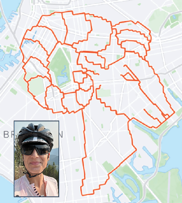
In November 2025, GPS artist Janine Strong drew a ram’s head by biking across the borough for 13 hours.
By JACK DELANEY | jdelaney@queensledger.com
They walk and bike among us, making strange loops in the park and cycling the wrong direction up one-way streets. You may have even honked at them — lost in thought, leaning over their handlebars to check their phones in traffic.
But for GPS artists like Janine Strong, who recently trekked 93 miles across Brooklyn in a single day, there’s a method to the madness. To them, the objective of exercise isn’t just posting a new PR or burning calories: it’s illustrating on a massive scale.
Strong, a native of Vancouver, CA, has made over 75 drawings since she started cycling seriously in 2019, using the satellite tracker built into the popular fitness app Strava as if it were an Etch-a-Sketch.
Sometimes, Strong picks a site with an idea already in mind — like when she drew a 40-mile-long “Big Apple” that stretched from Midtown to Forest Hills.
But for her latest creation in Brooklyn, Strong looked for shapes hidden in the map and spotted the makings of a ram.
“I got so much joy out of feeling like I found something in the streets that has essentially always been there, but has never been revealed before,” she told the Star.
After setting off from Flatbush, Strong quickly fashioned an ear. By the time she left East New York, the head was mostly formed. Fittingly, the neck involved a trip down to Sheepshead Bay. One horn curled around Prospect Park; she had to dismount in Greenwood Cemetery, which she called a “special place,” and stopped to chat with some fellow bikers. Next came the zigzag up to Downtown Brooklyn, before the horn continued its arc through Bed-Stuy and arrived at its base once more in Flatbush.
The sun had long since set: the whole trip took 13 hours and involved a cumulative 2,000 feet of elevation gained.
But this isn’t Strong’s first creative foray in Brooklyn — in fact, it’s not even the first farm animal she’s designed here.
Last year, Strong embarked on a month-long project of drawing the zodiac signs while staying in the borough. In short order, Strong’s bike painted a scorpion, a centaur, the scales of justice, and yes, a goat, on the canvas of Southern Brooklyn.
Other local projects have included a rendition of Vermeer’s classic “Girl with a Pearl Earring,” and a replica of another, more dubious masterpiece: “Comedian,” the banana duct-taped to a museum wall by Italian artist Maurizio Cattelan that sold for $6 million in 2019.
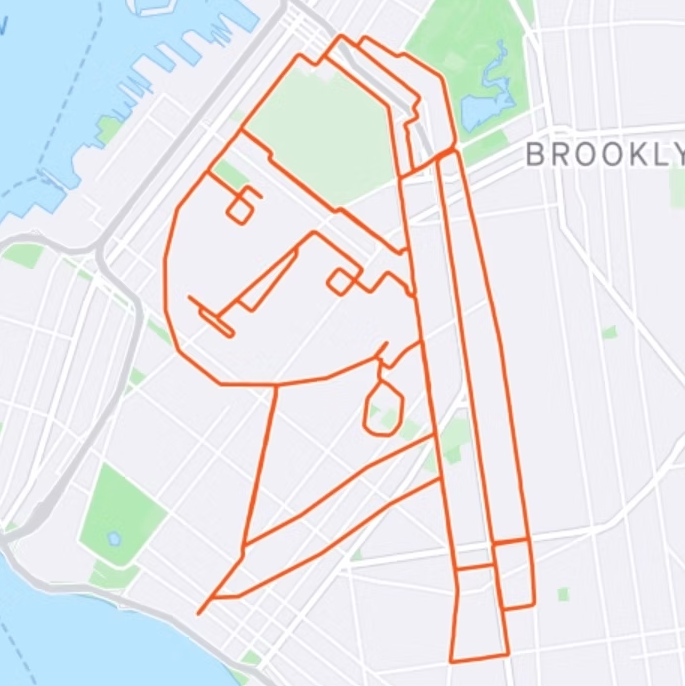
A series of drawings last year included this rendition of “Girl with a Pearl Earring” by Vermeer.
“If I’m going to the East Coast, I’ll definitely be spending time in Brooklyn,” said Strong. “It’s one of my favorite places to do GPS art.”
Strong, whose artistic practice also encompasses traditional drawing and photography, sees the constraints of the medium as part of its appeal. “[When I was younger] I would always draw straight with ink on paper, never with pencil,” she said. “Similarly, with GPS art you can’t erase anything. I loved the permanence of having to work with what happens and not change it.”
The community — equal parts obsessive, eclectic, and welcoming — is a deal sweetener. One of the earliest examples of GPS artists was Reid Stowe, who in 1999 undertook a 5,000-mile circumnavigation of the Atlantic Ocean in his sailboat, lasting 194 days without touching land as he slowly drew an enormous sea turtle with data recorded in his logbook. The next year, the US military opened its satellite signals to the public, and a digital iteration of the discipline took off.
With the advent of fitness apps, a new renaissance is now underway. “We support each other online,” explained Strong. “They’re all over the world, and we all have quite different approaches to things.” One man traces intricate drawing among sand dunes in Brazil; an Australian artist makes all his drawings in the same park, running free-form. In 2022, channeling Stowe, an Anglo-Italian couple brought their dog along as they traveled 4,500 miles to imprint a bicycle across Europe as a protest against fossil fuels.
For those interested in trying GPS art themselves, Strong has some practical advice.
While not essential, gear can make the long, erratic treks less daunting. “One thing that really increased my level of safety and comfort was getting this pair of glasses where there’s a little mirror in the left lens,” she shared. “So with a very short movement of my eye and my head, I can see exactly what’s happening behind me without having to turn my whole head.”
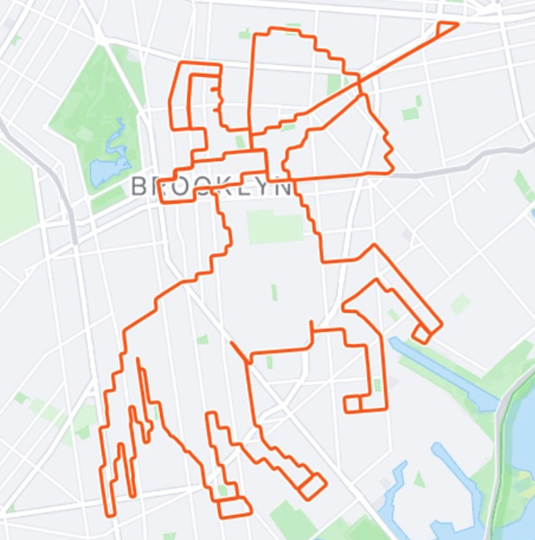
Another project: drawing the Zodiac signs, like this centaur representing Sagittarius.
To create curves and diagonal lines, GPS artists often have to work on large scales — much like how pixel artists have to increase the resolution to draw smoothly. But Strong sometimes makes use of a workaround in Strava: if you pause your session and move to a new location before pressing play again, the program will draw a straight line between the two points. (She executed one project, a star upstate in Ithaca, through this method exclusively.)
Strong designs all of her works digitally in the app, but you can also try websites like routedoodle.com and gpsartify.com that allow you to randomly generate ideas.
If you’re stumped, expand your horizons. “Some of the European cities have amazing canvases,” said Strong. “That’s part of what I love about it: every place is a totally new canvas, and you can’t draw the same thing in a different place.”